Meteorologist Danielle Noyes here with your Thursday Insights forecast. Before we get to the weather, a reminder: our 1DegreeOutside Weather Stream is now live – New England’s first continuous weather stream. Watch it on your smart TV (YouTube app, search 1DegreeOutside Network), at 1degreeoutside.live, or in the free app with the “Streaming Now” button right at the top.
Now to the weather.
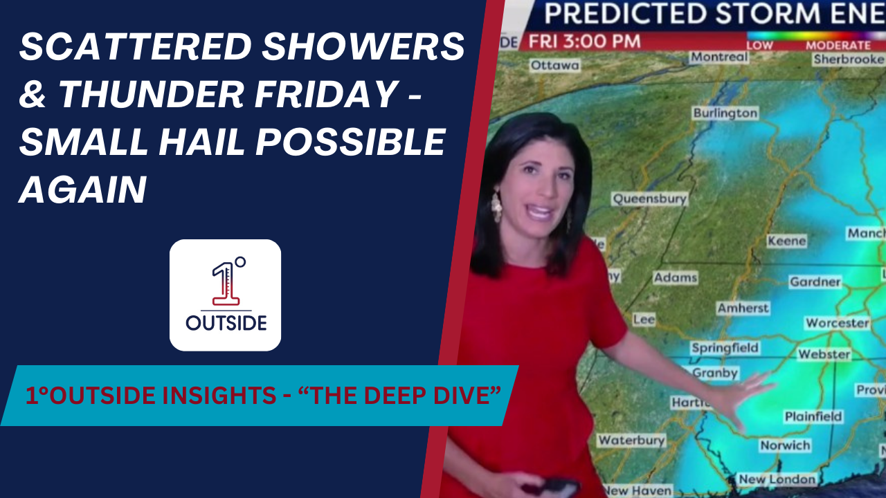
Friday brings the most unsettled conditions of the stretch. Cold air aloft slides over New England, creating just enough instability for thunderstorms. Highs will only be in the 60s north and lower to mid-70s south, but despite the cooler air at the surface, the contrast aloft will be enough to spark scattered storms from midday into the early evening. Expect lightning, brief gusty wind, and even small pea-size hail in stronger cells. Storm coverage will be scattered – not everyone sees one – and activity will taper Friday evening, giving way to patchy fog and a crisp night with 40s and 50s.
The weekend looks much better overall. Saturday still features some lingering northern showers, especially in northern Vermont, New Hampshire, and Maine, with more clouds in the North Country. Farther south, sunshine returns, highs reach the low 70s, and humidity remains low. Sunday starts crisp and sunny before bubbling clouds develop in the afternoon. Most are dry, though northern Maine could still see a passing shower. Highs reach the mid to upper 70s inland, a touch cooler along the coast with sea breezes.
Labor Day itself looks fantastic: sunshine mixing with a few clouds, inland highs 75 to 80, and low to mid-70s at the beaches thanks to the sea breeze. Humidity stays comfortably low – perfect for outdoor plans or a late-summer beach day.
Meanwhile, drought conditions continue to expand across New England. Rainfall over the last 30 days alone has run 2–3 inches below normal across much of the northern two-thirds of the region and along the South Coast. The latest U.S. Drought Monitor shows moderate drought now reaching into the Route 2 corridor and along the Massachusetts – New Hampshire and Vermont borders. Friday’s storms may bring localized downpours of a quarter to three-quarters of an inch, but they won’t provide the widespread soaking rain the region needs.
📲 Track Friday storms with interactive radar in the free 1DegreeOutside app. For members, the two-week dew point and feels-like forecasts, boating and golf discussions, and our Inside Track “Talking Up A Storm” podcast are waiting at membership.1degreeoutside.com.


