We’re threading a few needles this weekend – warm front, quick pulses of snow, a sharp northwest cutoff on Sunday – and then another round of Arctic cold early next week. If you’re watching on our 24/7 stream, you’ll see updates as new data comes in; for hyper-local timing down to your street, use Past+Future radar in the app.
Pockets of light snow this morning favor central, western and northern New England – then a relative lull. By late morning through about noon–5 PM, snow expands across western New England, with rain/mix for the South Shore/Cape and steadier light rain possible farther east. As temps drop late day/evening, any wet surfaces that are untreated will turn slick.
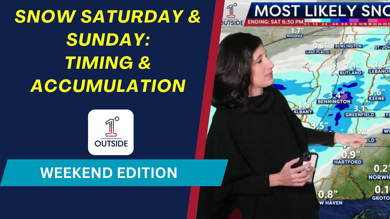
Saturday snow (general ranges):
Outside 495 / Merrimack Valley: slushy coating–1″
Northern Worcester Hills • SW NH • Southern VT (elevation favored): 2–4″, locally 4–6″; 6–8″+ on some summits
Far central & northern New England: broad 1–3″, 4–6″ pockets; lighter along the immediate ME coast
Eastern MA coast/Cape: mostly rain with a few flakes at the end; no accumulation
Sunday starts mostly quiet and above freezing, so impacts are minimal at first. As the steadier shield arrives during the afternoon, the freezing line sags south/east: Boston and Providence fall to freezing by ~6 PM, with a fluffier snow inland and a wetter, paste-type closer to the coast. The heaviest burst favors the South Shore → Cape/Islands Sunday evening; ending overnight, with just a few pre-dawn leftovers.
Sunday snow (early call; track tweaks possible):
Far northern New England / Champlain Valley: little to coating–1″
Western/central/northern New England (removed from core): 1–2″
Southern & far eastern New England (including southern NH): 1–2″ common
Immediate South Coast RI • South Shore • Cape & Islands: 2–4″ most likely
(We may tighten the gradient and/or nudge bands if the track jogs.)
Mid 30s dropping to low 30s, light wind. Snow expands late day – slicker late in the game; layer up.
Monday: 30s, a few mountain snow showers.
Monday night: Arctic front, single digits & teens, gusts 20–30 mph.
Tuesday: highs teens to low 20s; wind chills single digits/low teens
Watch the timing on our free app (1DegreeOutside Weather, App Store/Google Play), and catch live updates on our 24/7 channel (YouTube → 1DegreeOutside Network) or 1degreeoutside.live.


